NOTE: This activity is in the developmental stage, though almost complete. Graphics, formating, & proof reading have yet to be completed. Everything else is fully funcional, including the calculator and database tools. So, go ahead and use it!!
The purpose of this activity is allow students to practice measuring, communicating & collaborating with others on a research project, analyzing data, and drawing possible conclusions from/about any patterns they discover.
Most people think that the sun is directly overhead at noon. The truth is that this rarely happens. As a matter of fact, there are many places where this never happens (like Waukesha, Wisconsin). So where exactly is the sun in the sky? If you've never thought about it, you probably have never noticed. In this activity, you will measure how high the sun actually is above the horizon and then submit your findings to a database. Next, you'll look at other students' data and see if you notice any patterns. The rest of this page gives you the specific instructions you should follow.
This activity works best if many people make measurements at exactly the same time of day on (or close) to the same day. This being the case, you may want to contact friends, relatives, etc. who live in different states or countries and have them help you out by making measurements & posting their results as well.
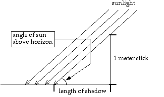
First, you need to measure how high the sun is above the horizon. Here's how you do that:
Now that you know the length of the meter stick's shadow, plug your measurement into the calculator below to determing the angle of the sun above the horizon.
In case you were wondering, the equation used to calculate the sun's angle above the horizon from the shadow length is

The last piece of information you need is your latitude (and longitude). If you don't alread know it, follow the steps below to find it.
Simply fill out the form below and send it on its way to add your information to the database.
You're almost done. Now that you have collected and submitted your own data, it's now time to look at other student's data from around the country/world. Click here to see all the data submitted by students. Your job now is to analyze the data to see if you notice any trends or patterns. One great way to analyze data is to use a graph. As a matter of fact, the first thing you will do is graph the angle of the sun compared to latitude. To do this, follow the instructions below.
Discuss the following questions with your classmates.
To receive credit for completing this activity, write a summary of your findings & present it to your teacher. Your summary should include the following information.